Functional Street Classification
Functional classification is the process to group roadways into classes according to the character of service they are intended to provide. Most travel involves movement through a network of roads or even modes. It is necessary to determine how travel can be channeled within the network in a logical and efficient manner. Functional classification defines the nature of this process by defining the part that any particular roadway should play in serving the flow of trips through the network.

A road classification is not solely based on the width of the road or its daily vehicle count. It is based mainly on how the roadway functions within the transportation system. The width of the road and vehicle count may be factors, but roadways vary greatly. A principal arterial in Middleton will look different than a principal arterial in downtown Boise, although the function is the same.
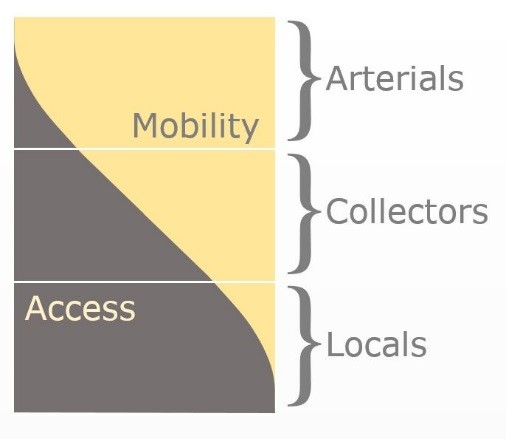
There are three basic categories of roadways: arterials, collectors, and local roads. This is the hierarchy in how the roadway system interacts with the land use system. Arterials function to move traffic. They have little – if any – access to land uses. The most prevalent example of an arterial is I-84. Collectors are the connectors in the roadway system. They have access to land uses, but also provide necessary movement. Some examples include Linder Road in Ada County and Locust Lane in Canyon County. Local roads give the greatest access to land uses and serve very localized purposes. The best example is the roadway in front of a home in a subdivision.
There are two separate functional classification maps: the planning map and the federal map. The planning map matches the regional long-range transportation plan process; therefore, it will follow the same time constraints as Communities in Motion. The federal map has a much shorter timeframe. The federal maps are typically updated every five years with a ten-year horizon. The maps will be similar, but the federal maps will only include the future designations through the ten-year horizon year.
